Sunday 15 June 2014

Leicestershire Round Part 7. Gumley to Shearsby

Well a lot of water has gone under the bridge since the last time we did any of the Leicester Round. We did parts 1 to 6 in the summer of 2010. Now four summers later we have three kids, two which can walk and a baby that goes into a child carrier. Our walk started in Gumley - a place that had ached in my memory due to the fact that we had got no further than this before. Every time I had surveyed a map of Leicestershire my eye would be drawn to Gumley and my mind play with the unfinished business that it signified. Today we would finally leave Gumley behind.
The start of the walk would take us through the church yard, but unable to find our way out we ended up sticking to the road and skirting around until we picked up the path to Saddington behind the village. 
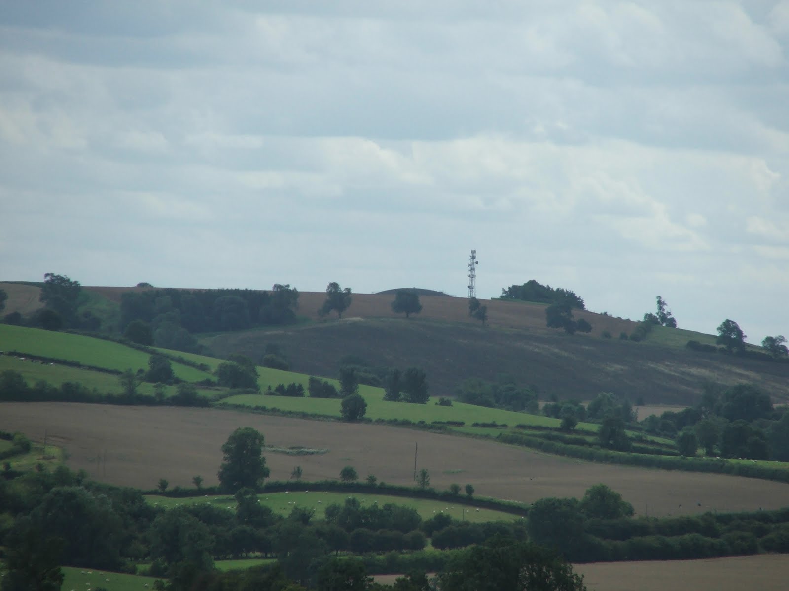
The path descends off Gumley Hill quite steeply. In front of you Saddington is clearly visible beyond Smeeton Hill. In fact Smeeton Hill is where we had our pack lunch - on the conveniently placed bench. It was also a good place to survey the landscape. My eye was initially drawn to the north, where Billesdon Coplow sticks up above the horizon (below). 
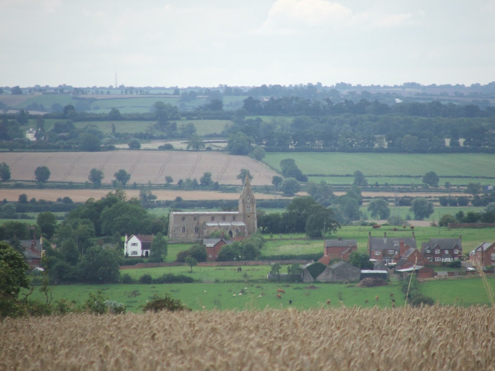
Further around to the east the square tower of the church at Church Langton could be seen (below) in front of the Langton Caudle. It was from here that I had first sighted Smeeton Hill back in 2010. 
Smeeton Hill is also the first place where you can see the four distinctive Gilmorton wind turbines (below). These did not exist back in 2010, but now serve as a handy landmark for working out which way it is to Lutterworth. 
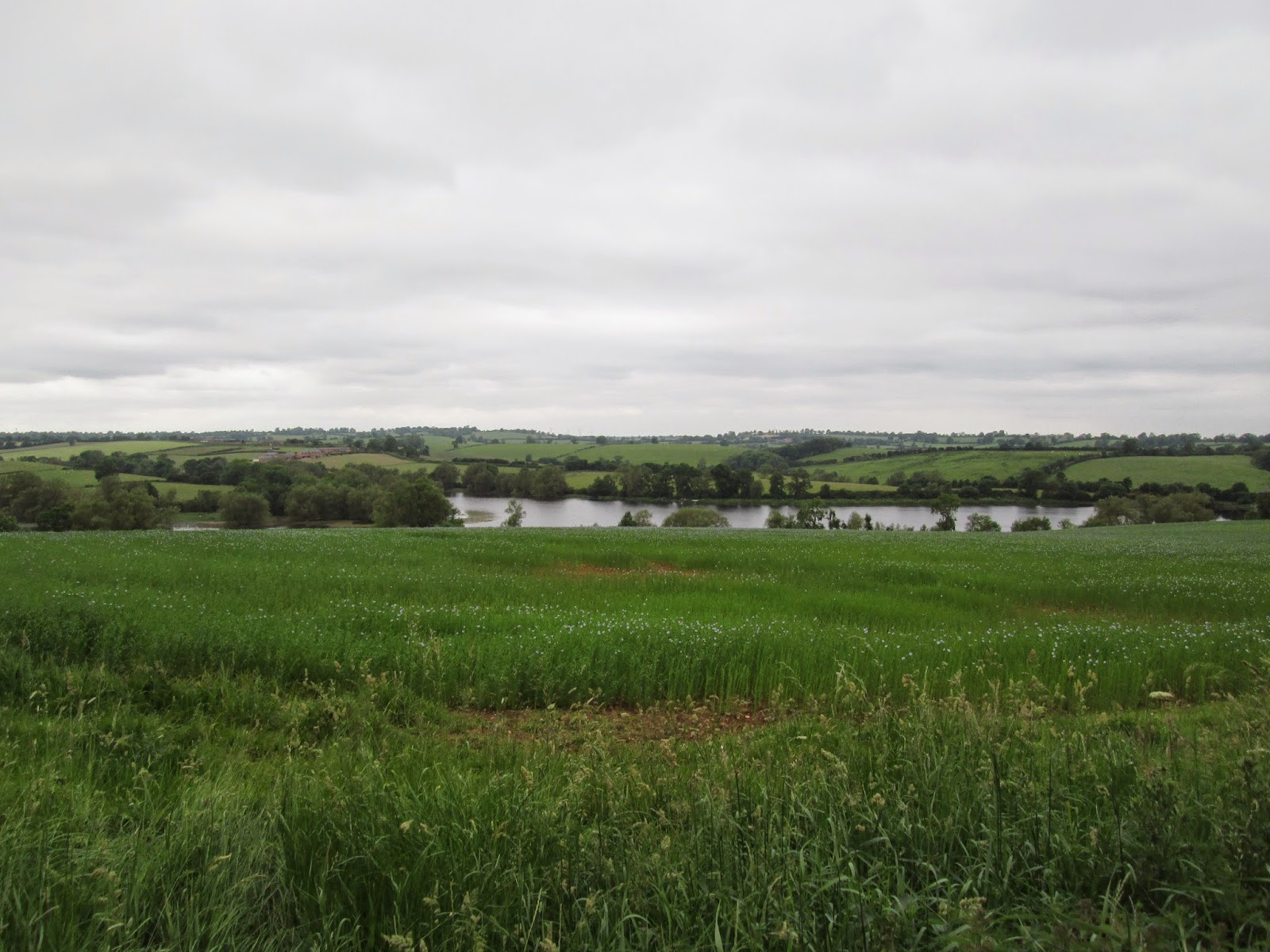
Descending down Smeeton Hill presents a few semi nice views of Saddington Reservoir. The linseed in the near-ground field is about a week or two before flowering - so there was the odd blue flower here and there.
After a fairly uneventful approach to Saddington we stopped at the Queen's Head and had a pint. The outdoor seating area was fine but there wasn't any slides or swings or anything for the kids. 
  The route out of Saddington featured field after field of featureless thistle infested meadow. You couldn't see beyond the field you were in and after a while you stopped caring where you were and only referred to the map when some interesting feature came into view. 
Of course there is one rural scene that I like even less than featureless meadow. That is featureless meadow with cows in it. When we got to within sight a farm that the map calls the Elms we entered a field that had a herd of young steers in it. Whilst I was busy trying to fasten the gate back up and my young family half way across the field the herd suddenly stampeded at them. I sprung into action (yes with baby on my back) sprinted to the space between the steers and my family and armed with my trusty quarter staff (yes ok walking stick) stood my ground. Suddenly I was surrounded by shoving, snorting aggressive animals (whilst behind me my kiddies were making for the gate. I gave it my best roar like a lion with the stick above my head - causing the whole herd to scatter in blind panic. Some towards my kids yet again. So I ended up sprinting after them (yes with a baby on my back) and finally headed the last two off and got my family out of there. Perhaps the worst encounter with cows I have ever had. I was left physically shaking. I did not want to see any more cows on this trip. But we did. in fact nearly every field from this point was full of them. 
  
STAMPEDE!
Eventually though the footpath approaches New Inn farm where there are horses. The footpath goes through an electrified paddock where horses are grazing. Still feeling a bit jittery after the episode with the cows we decided to skirt the outside of this on what looked like a horse track. Though sandwiched between a prickly hedge and an electric fence I did wonder what I would do if a 100 horses came bounding around the corner. Luckily for everyone - that did not happen and we ended up crossing the road and entering the village of Shearsby. 
Shearsby boasts a nice pub and a large green, with a small playground. 


Sunday 29 August 2010

Leicestershire Round part 6. Hallaton to Gumley.

Walk 6 of the Leicestershire Round would take us steadily downhill towards the river Welland. Offering us views into Northamptonshire. We set off from Hallaton.
In front of us as we left the village was the impressive earthwork of Hallaton Castle. This 12th Century motte and bailey castle, built during the reign of King Stephen is thought to have been built as a display of wealth rather than a serious defensive stronghold. The earth works are clearly visible ahead as you pass the cemetery.
The path climbs up over a north bluff of the River Welland until at its top you begin to get a view forwards towards the rest of the days walk. From this spot we got our first view of Langton Caudle. This 147m hill stands alone and offers fantastic views over this part of Leicestershire, which I will talk about in a minute.
Before you get to Langton Caudle you cross the route of the roman road known as the Gartree Road. This ancient road linked Leicester to Cambridge. In the field itself there really isn't any sign of it, though you can make out its course on Google Earth.
The path climbs up the Caudle on its north side. The view opens out at the summit.
From the top of the Caudle my attention was drawn in the first instance towards the north. The distinctive domed reservoir atop of Whatborough Hill just visible above a foreground ridge.
To the east we could see the dramatic sweeping side of the Welland Valley as it curves north eastwards. The River Welland marks the boundary between Leicestershire and Northamptonshire. The far bank of the Welland Valley is therefore across the boarder.
A close up of the Welland Valley shows Cottingham Church spire on the right and Rockingham Castle on the left.
Further around to the south Market Harborough can be seen quite clearly.
In the near-ground the church at Thorpe Langton sits resplendent in the valley.
Towards the south the green tree covered hill left of centre in this picture is Sibbertoft Wood, in Northamptonshire.
Further west of that the ridge gains a set of distinctive spinneys. This is Hothorpe Hills in Northamptonshire. The white building in front of that is a prison on Gallow Field Road. How apt.
To the west the Church at Church Langton is clearly visible. Behind it Smeeton Hill. On the next walk we will be walking over Smeeton Hill.
After peering at distant hill for a while we then began the descent towards Thorpe Langton. This part of Leicestershire is pasture and we encountered several bulls on our travels.
From Thorpe Langton the Langton Caudle looks nothing more than a slight hill to the north.
Thorpe Langton cows.
After leaving Thorpe Langton and passing through East Langton we ended up in the Welland flood plain. We crossed several streams that drain into the Welland and they were all swollen with the recent rain we have enjoyed. A quick look over to the west reveals Gumley, our destination on this walk.
Also visible is the church at Foxton. The famous locks of Foxton are not visible from this angle.
The path then led under the railway and across the A6. Another daring road crossing required!
The season is really mature now and the crops in all the fields are ready for harvest. This Oil Seed Rape was being harvested whilst we were there.
Upon getting to Foxton we then followed the canal. The late afternoon sunshine made this last bit really tranquil.
The Locks at Foxton are worth seeing. We rested here in the pub on the left. Both pubs are nice, but I prefer the local Langton Ales that the other pub has on tap.
The locks are always busy with boat people and tourists.
A short way down the canal we crossed over this bridge into a few more paddocks.
At the end of a long days walking finding the car and sitting down with a flask of tea was a luxury!

Wednesday 25 August 2010

Leicestershire Round part 5. Launde to Hallaton

Our walk started from Launde Abbey and headed east past these nosey cows!
The path passed Launde Park Wood to the north. The early morning sunshine and due covered spider webs made this part quite magical.
The path then abruptly turned south and headed uphill. From here on the far eastern horizon you can see Rutland Water (above).
From the other side of the hill Eyebrook Reservoir can be seen in the South East.
The path joins a very quiet road and down to Belton-in Rutland. We stopped here for some sandwiches.
From here a daring crossing of the A47 has to be attempted before entering the village of Allexton (above).
From Alexton you then begin to climb again. From the hill looking over Allexton Hall you get a good view back to Belton and Owston Woods beyond.
The corn in the fields was ripe for harvesting. In some fields they were actually harvesting it.
Flax growing in the path. In the open soil of the footpath flax seeds from a previous crop have grown into a purple carpet. Pretty but a little prickly for the short wearer.
One last look north gives a last glimpse of Whatborough Hill. I don't think we will see the hills of east Leicester again for a while.
Then to the south Hallaton appears. Slawston Hill stands just beyond.
Again we cross the dismantled train line.
The pub at Hallaton.


Leicestershire Round part 4. Burrough to Launde.

Starting from the carpark at Burrough we headed north across the fields that run along the country parks eastern boarder. After these the path plunges off the edge of the hill and down into woodland.
This woodland leads east for a couple of km before bringing you back to the hill edge at Punch Bowl Covert.
The climb up Punch Bowl Covert is steep.
Once ontop of the hill again the path marches endlessly southwards through fields of dwarf corn onto the distant spire of Somerby Church.
After quickly passing through the village of Somerby you are presented with a view across a valley to Owston and the hills beyond. The stream you cross hear drains westward towards the Soar and thus enters the sea by the River Humber. Owston marks the watershed where water starts draining eastwards toward the Wash.
The view forward shows the east leicestershire hills from the north. The picture above shows Colborough Hill. This is one of the easier hills to recognise because of the wood that half covers it.
One of the tallest hills is slightly harder to spot from this perspective. Whatborough Hill at 230m is one of the tallest but lacks features. A discerning eye might be able to spot the dome of a Severn Trent water reservoir that sits at the top of it. The third hill of the trio sits just behind these and so can't be seen from the north.
Considering the fact that we were now walking across the ironstone upland in the east of the county the views westward were nearly always obscured. Once or twice you could see a reasonable distance, like in the photo to Beacon Hill (above).
Owston is an all to brief punctuation mark of civilisation.
It is becoming more and more apparent that the season is maturing. The sloe berries abound.
A few more fields and the northern horizon darkens. Owston Wood creeps ever closer like a green tidal wave. The footpath cuts through the wood. The stream that you cross here drains into Rutland Water to the east.
Now, the guide book said the wood was very, very wet but surely in summer it would have dried out? That is what I thought before we entered. The reality was exactly as the guide book suggested. The wooded path was unbelievably wet. The soil was like soup. Great ankle deep and water filled footprints betrayed a recent history of walkers almost loosing their boots. The path was at quite a slope and yet the water did not seem to be able to drain away. It was bazaar. I commented at the time that it was like water sticking to a 45 degree slope.
After clearing the wood, we then went through Withcote Hall farm. Where we were investigated by piglets, horses and my worst nightmare - an untethered Alsation. It was one of those run or fight moments. We stood our ground and I did my best "Hello friendly dog, good boy, good boy" and it seemed to do the trick.
Being the other side of the wood now allows you to see the third hill in the trio called Robin a tiptoe hill. This flat topped hill is distinctive because it is so flat topped. It is also prominent from the A47.
Colborough Hill from the east is quite obvious also. Whatborough is obscurred by the woodland from here.
This picture shows the "three peaks" of Leicestershire's Jurrasic ridge. Robin-a-Tiptoe Hill on the left, Colborough Hill in the middle and Whatborough on the right. All three have been a hillfort at some point in the past. Its just a shame no right of way was established up any of these hills.
The path now crosses a few more fields and the River Chater. This river misses Rutland Water and drains streight into the Welland and out into the wash.
The days walk ended at Launde Abbey. This impressive Tudor house is now a retreat house owned by the Diocese of Leicester. Its a tremendously peaceful place.